Jayakar Committee : British government Passed a resolution in 1927, in response to which Jayakar Committee was constituted in 1927. Jayakar committee proposed that an extra tax should be levied on petrol to develop a fund called "Central Road Fund".
Recommendations made by Jayakar Committee
1. The road development in the country should be considered as a national interest as this has become beyond the capacity of provincial government and local bodies.
2. An extra tax should be levied on petrol from the road user to develop a road development fund called Central Road Fund.
3. An semi official technical body should be formed to pool technical know how from various parts of the country and to act as an advisory body on various aspects of roads.
4. A research organization should be instituted to carry out research and development work and to be available fro consultations.
Steps taken by Government :
1. The Central Road Fund was formed on 1st March 1929.
2. A semi official technical body known as Indian Road Congress (IRC) was formed in 1934.
3. In 1939 Motor Vehicle Act was started and in 1950 Central Road Research Institute (CRRI) was started. Motor Vehicle Act has been revised in the year 1988.
4. National Highway Act was brought in 1956.
5. Highway Research Board was setup in 1973, with view to give proper direction and guidance to road research activities in India.
6. National Transport Policy committee in 1978.
Central Road Research Institute : In the year 1950, the Central Road Research Institute (CRRI) was started at New Delhi for research in various aspect of highway engineering. The CRRI is one of the national laboratories of the Council of Scientific and Industrial Research the institute is mainly engaged in applied research and offers technical advice to state governments and the industries on various problems concerning roads.
National Highway Act : In the 1956 the National Highway Act was passed.
Features :
Indian Road Congress (IRC) has played important role in the formation of the last three 20 years road development plans in India.
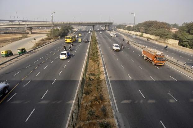
1. Nagpur Road Plan : In this first 20 years road development plan, also know as Nagpur Road Plan, all roads were classified into five categories and a twenty year development programme for the period 1943 - 63 was finalized. A conference of the Chief Engineer of all the states and provinces was convened in 1943 by the Government of India at Nagpur, an initiative of the Indian Roads Congress to finalise the first road development plan for the country as a whole.
Features :
(a) The Nagpur road plan formulae were prepared on the basis of "Star and Grid" pattern.
(b) The total road length of 5,32,700 km with a density of 16 km of road length per 100 square km area would be available by 1963.
(c) The roads are classified into 5 categories.
(d) The length of the railway tracks in the area was considered within the road length. Hence net road length is calculated by subtracting length of railway track from the length of metalled road.

A = Agricultural Area in square km
B = Non Agricultural Area in square km
N = Number of towns and villages with population range 2001 - 5000
T = Number of towns and villages with population over 5000
D = Development allowance of 15 percent of road length calculated to be provided for agricultural and industrial development during the next 20 years.
R = Existing length of railway track in km
The total length of second category roads for Other District Roads and Village Roads in km is given by the formula.


National Highway + State Highway

National Highway + State Highway + Major District Roads
National Highway + State Highway + Major District Roads + Other District Roads

National Highway + State Highway + Major District Roads + Other District Roads + Village Roads

A = Developed and Agricultural Area in square km
B = Semi Developed Area in square km
C = Undeveloped Area in square km
K = Number of towns with population over 1,00,000.
M = Number of towns with population range 1,00,000 - 50,000
N = Number of towns with population range 50,000 - 20,000
P = Number of towns with population range 20,000 - 10,000
Q = Number of towns with population range 10,000 - 5,000
R = Number of towns with population range 5,000 - 2,000
S = Number of towns with population range 2,000 - 1,000
T = Number of towns with population range 1,000 - 500
V = Number of towns with population below 500
D = Development allowance of 5 percent of road length calculated for further development and other unforeseen factors.
3. Lucknow Road Plan : In this plan, roads are classified into primary, secondary and tertiary road systems. all villages with over 500 population should be connected by all weather roads. The overall road density was targeted as 82 km per 100 square km area.
The National Highway network should be expanded to form square grids of 100 km sides so that no part of the country is more than 50 km away from a National Highway. Express way should be constructed along major traffic corridors to provide fast travels. There should be improvement in environmental quality and road safety.
To calculate the total length of National Highway the formula is given below. Lucknow Road plan includes express ways of total length 2000km, National Highway based on the concept of 100 km square grids i.e. 100 + 100 = 200 km of National Highway length are provided per 100 X 100 = 1000 square km area. This means 1 km per 50 square km area.
Total length of National Highway
= Area of country / 50
= 32,87,782 / 50
= 66000km
To calculate the total length of State Highway and Major District Roads use the given formula given below
Length of State Highway = Area of State / 25 OR 62.5 x No. of towns in state - length of National Highway
Length of Major District Roads = Area of state / 12.5 OR 90 x No. of towns in state
Recommendations made by Jayakar Committee
1. The road development in the country should be considered as a national interest as this has become beyond the capacity of provincial government and local bodies.
2. An extra tax should be levied on petrol from the road user to develop a road development fund called Central Road Fund.
3. An semi official technical body should be formed to pool technical know how from various parts of the country and to act as an advisory body on various aspects of roads.
4. A research organization should be instituted to carry out research and development work and to be available fro consultations.
Steps taken by Government :
1. The Central Road Fund was formed on 1st March 1929.
2. A semi official technical body known as Indian Road Congress (IRC) was formed in 1934.
3. In 1939 Motor Vehicle Act was started and in 1950 Central Road Research Institute (CRRI) was started. Motor Vehicle Act has been revised in the year 1988.
4. National Highway Act was brought in 1956.
5. Highway Research Board was setup in 1973, with view to give proper direction and guidance to road research activities in India.
6. National Transport Policy committee in 1978.
Central Road Research Institute : In the year 1950, the Central Road Research Institute (CRRI) was started at New Delhi for research in various aspect of highway engineering. The CRRI is one of the national laboratories of the Council of Scientific and Industrial Research the institute is mainly engaged in applied research and offers technical advice to state governments and the industries on various problems concerning roads.
National Highway Act : In the 1956 the National Highway Act was passed.
Features :
- The responsibility of development and maintenance of the National Highway to be provisionally taken by the Central Government.
- The central Government to be empowered to declare any other highway as National Highway or to omit any of the existing national highway from the lists.
Indian Road Congress (IRC) has played important role in the formation of the last three 20 years road development plans in India.
1. Nagpur Road Plan : In this first 20 years road development plan, also know as Nagpur Road Plan, all roads were classified into five categories and a twenty year development programme for the period 1943 - 63 was finalized. A conference of the Chief Engineer of all the states and provinces was convened in 1943 by the Government of India at Nagpur, an initiative of the Indian Roads Congress to finalise the first road development plan for the country as a whole.
Features :
(a) The Nagpur road plan formulae were prepared on the basis of "Star and Grid" pattern.
(b) The total road length of 5,32,700 km with a density of 16 km of road length per 100 square km area would be available by 1963.
(c) The roads are classified into 5 categories.
- National Highway
- State Highway
- Major District Roads
- Other District Roads
- Village Roads
(d) The length of the railway tracks in the area was considered within the road length. Hence net road length is calculated by subtracting length of railway track from the length of metalled road.
- The total length of the first category or metalled roads for National and State Highway and Major District Roads in km is given by the formula.
A = Agricultural Area in square km
B = Non Agricultural Area in square km
N = Number of towns and villages with population range 2001 - 5000
T = Number of towns and villages with population over 5000
D = Development allowance of 15 percent of road length calculated to be provided for agricultural and industrial development during the next 20 years.
R = Existing length of railway track in km
The total length of second category roads for Other District Roads and Village Roads in km is given by the formula.
V = Number of villages with population 500 or less.
Q = Number of villages with population range 501 - 1000
P = Number of villages with population range 1001 - 2000
S = Number of villages with population range 2001 - 5000
D = Development allowance of 15 % for next 20 years.
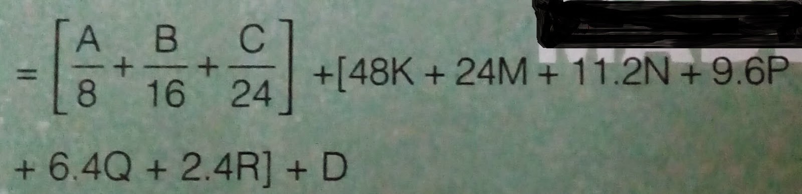
2. Bombay Road Plan : As the earlier target was achieved before the planned year, so a need to set a new target arises and another 20 years road plan was laid down at the meeting of the various authorities from different states at Bombay. The road density target was doubled this time.
Features :
(a) At the end of plan, the target road length aimed was 32 km per 100 square km area.
(b) Maximum distance of any place in a developed or agricultural area would be 6.4 km from a metalled road and 2.4 km from any category of roads.
(c) Every town with a population above 2000 in plains and above 1000 in semi hill areas and above 500 in hilly areas should be connected by metalled road.
(d) 1600 km Express way have been considered in this plan within proposed target of National Highway.
(e) Length of railway track is considered independent of the road system and hence it is not subtracted to get the road length.
(f) A development factor of 5 % is provided for future developments.
It should be noted that allowance for development of agriculture and industry during the next 20 years was made in nagpur plan allowing 15 % increase in the calculated road length. This allowance according to the second plan is 5 % only.
Different formulae for to calculate the length of National Highway, State Highway, Major District Roads, Other District Roads and Village Roads.
National Highway
National Highway + State Highway
National Highway + State Highway + Major District Roads
National Highway + State Highway + Major District Roads + Other District Roads
National Highway + State Highway + Major District Roads + Other District Roads + Village Roads
A = Developed and Agricultural Area in square km
B = Semi Developed Area in square km
C = Undeveloped Area in square km
K = Number of towns with population over 1,00,000.
M = Number of towns with population range 1,00,000 - 50,000
N = Number of towns with population range 50,000 - 20,000
P = Number of towns with population range 20,000 - 10,000
Q = Number of towns with population range 10,000 - 5,000
R = Number of towns with population range 5,000 - 2,000
S = Number of towns with population range 2,000 - 1,000
T = Number of towns with population range 1,000 - 500
V = Number of towns with population below 500
D = Development allowance of 5 percent of road length calculated for further development and other unforeseen factors.
3. Lucknow Road Plan : In this plan, roads are classified into primary, secondary and tertiary road systems. all villages with over 500 population should be connected by all weather roads. The overall road density was targeted as 82 km per 100 square km area.
The National Highway network should be expanded to form square grids of 100 km sides so that no part of the country is more than 50 km away from a National Highway. Express way should be constructed along major traffic corridors to provide fast travels. There should be improvement in environmental quality and road safety.
To calculate the total length of National Highway the formula is given below. Lucknow Road plan includes express ways of total length 2000km, National Highway based on the concept of 100 km square grids i.e. 100 + 100 = 200 km of National Highway length are provided per 100 X 100 = 1000 square km area. This means 1 km per 50 square km area.
Total length of National Highway
= Area of country / 50
= 32,87,782 / 50
= 66000km
To calculate the total length of State Highway and Major District Roads use the given formula given below
Length of State Highway = Area of State / 25 OR 62.5 x No. of towns in state - length of National Highway
Length of Major District Roads = Area of state / 12.5 OR 90 x No. of towns in state


